
The HELIX 7 CHIRP SI GPS G2 is similar has quite a few extra features to offer over the last year’s HELIX 7 SI GPS unit. First of all, the new HELIX model has CHIRP sonar technology, second of all, it has the AC Live feature, and third, it’s SmartStrike capable.
With regards to its fish finding features, the first aspect to mention here is that the unit comes with the XNT 9 SI 180 T transducer, which can also detect water temperature. This transducer supports all three sonar technologies of the unit, DualBeam Plus, Side Imaging and Down Imaging.
With the supplied transducer, the unit can use two frequencies for DualBeam Plus, 83 kHz, and 200 kHz. For these frequencies, the transducer uses conical beams with a coverage of 20° for 200 kHz, and 60° for 83 kHz. Also, since it’s a CHIRP unit, the sonar pulse is modulated over a range of frequencies between 75-95 kHz, and 175-225 kHz.
For SI and DI, the system can scan at a frequency of 455 kHz, with a CHIRP modulation of 420-520 kHz. The side beams used by the Side Imaging sonar can extend up to 240 ft on each side of the boat. Their coverage is 86°.
The unit’s depth capability isn’t too great for Side Imaging and Down Imaging. For these types of sonar, the system can only scan depths up to 150 ft (45 m). However, for DualBeam Plus, its depth capabilities are much greater, being able to reach depths up to 1,500 ft (457 m). Also, with a 50 kHz capable transducer, the system can reach depths up to 2,500 ft.
Just as the other HELIX units, this particular model has functions such as Selective Fish ID, Real Time Sonar, SwitchFire etc. However, it does not support 360 Imaging sonar.
The unit’s navigation functions include a fast and accurate internal GPS, and the UniMap charts. These charts are the most basic Humminbird charts, but the unit’s carts can be upgraded to LakeMaster or Navionics Gold. It’s also compatible with the SmartStrike fishing charts.
One important navigation function with fishing applications that we must mention here, is AutoChart Live. This function allows you to map the contours of a certain lake, reservoir or river, using the 2D sonar and GPS data. So, in case the charts of the unit do not cover your favorite lake, you can always use this function to benefit from the most up to date depth contours. The unit can also save up to 2,500 waypoints, 45 routes and 50 tracks (with up to 20,000 points per track).
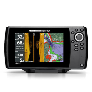
Last but not least, the control unit features a 7-inch display, 16-bit color, with a pixel resolution of 800 x 480. It’s IPX7 waterproof and integrates LED backlight. It’s NMEA 0183 capable, and also has a microSD card slot for charts upgrades or recordings and backups. It does not have an Ethernet port, though. And finally, it comes with a classic gimbal mount, but there’s also the option of an in-dash mount.
